
If you thought summer was done and over with, think again!
While Labor Day is the unofficial end of summer in Michigan, it actually doesn't end until later this month -- and this week is proof.
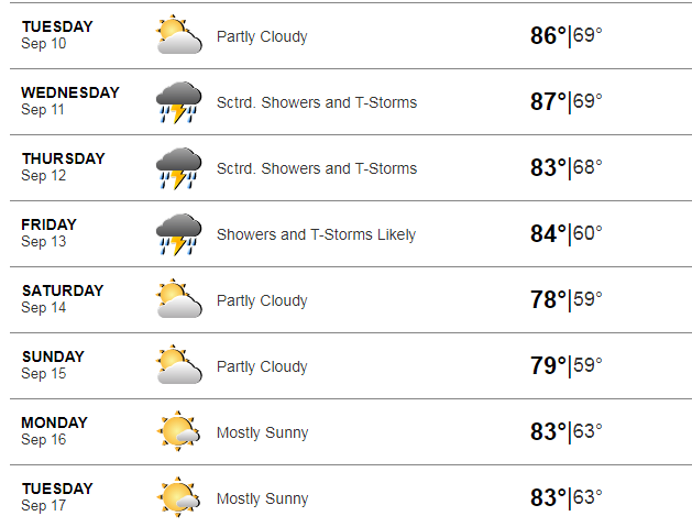
Temps are going to quickly warm up on Tuesday to near 90 degrees (yes, 90 degrees!) and it'll stick around. Take a look at the upcoming forecast below:
Here's more from Local 4Caster Brandon Roux:
Tuesday forecast
An impressive warm front blows in here tomorrow and Wednesday highs may be 15° warmer than what we feel out there today. Summer comes back for a short while as morning lows near 60 degrees will warm into the low and even middle 80s Tuesday afternoon around Metro Detroit.
Wednesday forecast
The humidity will have the heat index near 90°F Tuesday and Wednesday, and we can never trust a warm front. One model brings in a few showers tomorrow, but we expect most of the day to be dry other than an isolated shower. Highs in the low to mid 80s and winds SW 10-20 mph gusting tomorrow afternoon. Drink plenty of water!
The shower and storm chances increase Wednesday through Friday this week and it looks like most of the rain and thunderstorms will get started Wednesday afternoon with the peak heat of the day as highs hit the mid 80s feeling even warmer.
Expect shower chances coming and going toward the end of this work and school week, keeping highs in the low 80s at least.
Thursday, Friday forecast
Some of the heaviest rain ahead according to early morning model data looks to be late Thursday through the first half of Friday before we start to dry out and cool down. The weekend ahead looks mainly dry with temps more seasonal in the mid 70s.