
As I mentioned yesterday, the computer models have performed horribly over the past week in regards to projecting where batches of severe storms would blow up and, eventually, track. But based upon my past experience with these types of systems, as well as what I’ve seen from the models today, I think I have a reasonable handle on how things will develop later tonight.
First of all, we’ll have a beautiful summer Friday evening…hope you can enjoy it. Most of the night will be dry, but rain and thunderstorms will approach late at night. It appears to me that the best chance to see severe weather (mostly, a damaging wind threat) will be on the southern part of the thunderstorm complex, so those of you in Lenawee and Monroe Counties, and perhaps even up to I-94, have the best chance to see some severe weather. Farther north, the risk is more marginal…but keep in mind that if the complex tracks just a little farther north than projected, that would bring the severe storm risk farther north. The Storm Prediction Center’s outlook for tomorrow, which you see at the top of this article, has a pretty good representation of our severe risk.
Recommended Videos
If severe weather does move into our area, it will likely be when many of us are still asleep. So make sure that your weather radio is turned on and set to alert before you go to bed. I’ll tweet a personal update if there’s anything new to report later this evening before we go to bed so, for those of you on Twitter that follow me at @PGLocal4, watch for that update.
It’ll be another uncomfortably warm sleeping night, with lows in the upper 60s to near 70 degrees (20-21 degrees Celsius), and no breeze coming in the windows to help those without air conditioning.
Saturday morning looks to be stormy for some, but rainy at the least for the rest of us. Based upon my experience with this special type of thunderstorm complex (called an MCS, or Mesoscale Convective System), I think it’ll pass by and we’ll dry out for the afternoon. While some forecasts have talked about thunderstorm redevelopment in the afternoon, my experience has been that these MCSs stabilize the atmosphere enough that we probably won’t see much redevelopment Saturday afternoon. In fact, don’t be surprised if we see a few breaks of sun later in the day. As long as this forecast holds, your Saturday evening “date night” plans should be fine. Highs Saturday in the low 80s (28 degrees Celsius), unless the sun comes out earlier in the afternoon…then we’d warm up some more. East-northeast wind at 5 to 10 mph.
Saturday’s sunrise is at 6:17 a.m., and Saturday’s sunset is at 9:02 p.m.
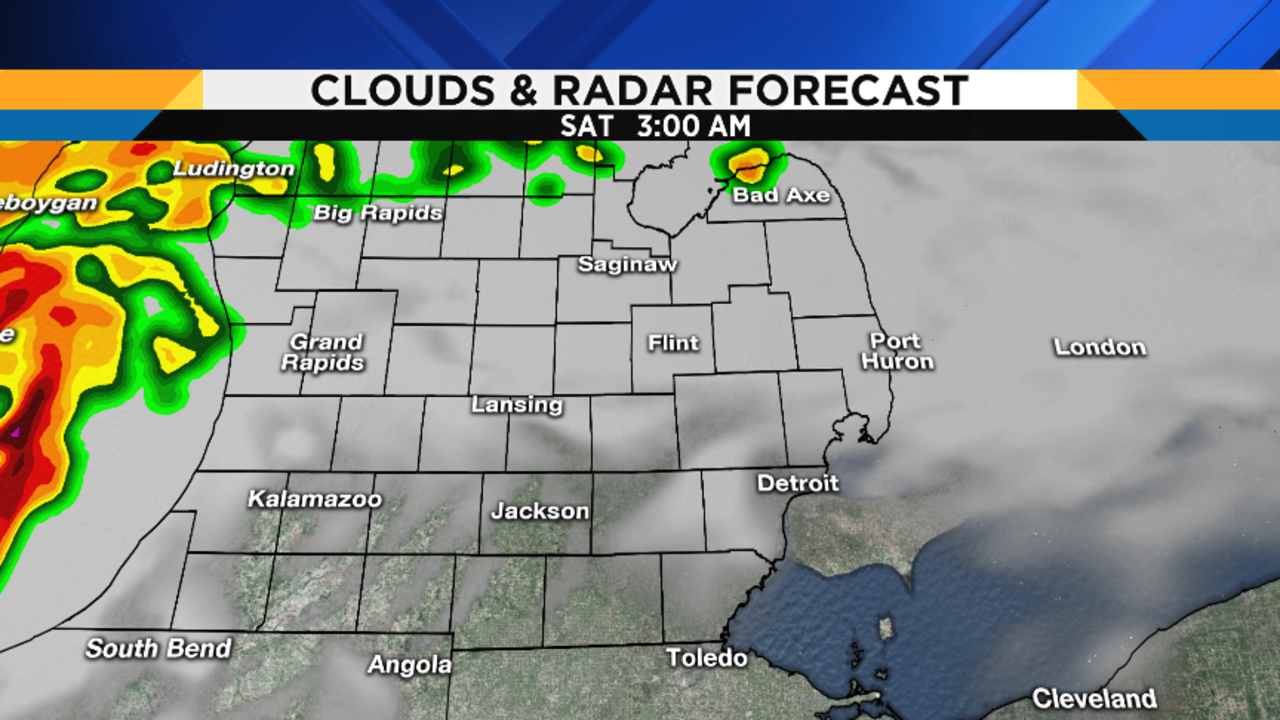
Here is how Local 4’s in-house RPM model is handling the Saturday storm scenario, followed by a total rainfall forecast map, where you’ll see that the highest rain totals (1-2”) are projected to be in the far south:


Mostly cloudy (perhaps even partly cloudy at times) Saturday night, with lows near 70 degrees (21 degrees Celsius).
If today’s models are correct, we’ll start Sunday dry, and then see thunderstorms pop up in the afternoon. A few of those storms could also become severe, so make sure to check the radar on our FREE Local4Casters app often if you have outdoor plans. Naturally, I’ll continue to tweet personalized updates to those of you who follow me on Twitter. Muggy highs Sunday in the mid 80s (30 degrees Celsius).
Thunderstorms and rain showers gradually end Sunday night, with lows in the mid 60s (18 degrees Celsius).
Finally, relief arrives Monday in the form of cooler temperatures and lower dewpoints (meaning lower humidity). It looks to be a partly cloudy day, with refreshing highs in the upper 70s (26 degrees Celsius). I know a few WDIV Fighting Peacocks who will be most pleased with me at our softball game Monday evening…
Mostly clear Monday night, with lows near 60 degrees (16 degrees Celsius) in the bigger cities, and in the upper 50s in rural locations.
Mostly sunny on Tuesday, with highs near 80 degrees (27 degrees Celsius).
Mostly clear Tuesday night, with lows in the mid 60s (17 degrees Celsius).
Mostly sunny on Wednesday, with highs in the mid 80s (29-30 degrees Celsius).
The cold front I’ve been telling you about all week long now appears to be coming through the area Wednesday night, as opposed to during the day on Thursday. As such, with cooler nighttime temperatures providing a more stable atmosphere, we might not get any showers out of this front. As long as this new timing holds, we’ll have plenty of sunshine from Thursday through Sunday, with highs in the low to mid 80s (28-30 degrees Celsius), and overnight lows in the low to mid 60s (17-18 degrees Celsius).
Up North Forecast
For those of you who are up north this weekend, here are some maps to help you plan:


One More Word About the Computer Models
Yesterday, I wrote extensively explaining the poor performance of the computer models this past week in handling the genesis and movement of big clusters of thunderstorms. To give you an example of what I’ve had to deal with this past week, take a look at the three computer models below. These are three different runs of yesterday’s model (8:00 a.m., 11:00 a.m. and 2:00 p.m.), projecting the weather for 4:00 p.m. yesterday. Look at how different they are! Now I hope you appreciate the difficulty that I (and all meteorologists) sometimes have when forecasting your weather. On weeks like this, I have to rely more upon experience than upon the models themselves.


