DETROIT – The Local4Casters have been showing you for days now how we’ll have a close call with Harvey’s remnants, and that close call is almost upon us. We’ve certainly seen some high, thin cirrus clouds today, but some thicker clouds will move into part of the area as we head into the first part of the holiday weekend.
Expect partly cloudy skies tonight, as bands of those cirrus clouds come and go. Lows in the low to mid 50s (11-12 degrees Celsius). Northeast wind at 5 to 10 mph. Tonight begins the Muslim Holy Day of Eid al Adha, also known as the Feast of Sacrifice, which represents the end of Hajj, an annual Islamic pilgrimage to Mecca in Saudi Arabia. The day (it continues through Saturday) is one of the holiest celebrations on the Islamic calendar, and is a public holiday in many Muslim countries. The weather will cooperate if you’ll be celebrating and, if you are, I wish you a joyous and meaningful holiday!
Saturday’s cloud cover will vary across the area. Those of us to the south and east will see some thicker “Harvey clouds” push into the area, while those of us to the north and west will hang onto more filtered sunshine. Highs in the upper 60s to near 70 degrees (20-21 degrees Celsius), with an east wind at 5 to 10 mph. It looks pleasant for Arts, Beats and Eats in Royal Oak!
Saturday’s sunrise is at 7:00 a.m., and Saturday’s sunset is at 8:05 p.m.
Mostly cloudy to the south and east Saturday night, with an isolated light shower even possible. Areas to the north and west will remain partly cloudy. Lows in the mid 50s (13 degrees Celsius).
Partly cloudy and warmer on Sunday. As we showed you yesterday, a cold front will approach, but today’s computer models are now pretty much washing that front out so, at this point it looks like yet another great day at Arts, Beats and Eats! Highs in the upper 70s (26 degrees Celsius).
Mostly clear Sunday night, with lows in the low 60s (16 degrees Celsius).
The timing for Monday’s cold front still hasn’t changed. Most of our Labor Day should be dry and becoming windy, with highs in the mid 80s (29 degrees Celsius). However, there is a chance for some thunderstorms either very late in the afternoon, or into the evening hours. If you have outdoor plans, perhaps heading out to Arts, Beats and Eats, or having a barbecue, I’d keep your phone with our Local4Casters app handy. If you don’t have the app, you can download it for free from the App Store…just search under WDIV. If you already have the app, have you updated to our latest version? If so, you’ll get a push-alert when lightning occurs within five miles of your location. It’s a great tool to keep you ahead of dangerous weather.
This cold front will knock temperatures back down for the rest of the work week, with highs back to near 70 degrees (21 degrees Celsius) on Tuesday, only in the mid to upper 60s (19-20 degrees Celsius) on Wednesday and Thursday, then back to near 70 degrees (21 degrees Celsius) on Friday.
My long range models suggest that next weekend looks spectacular, as temperatures continue to warm!
Hurricane Irma
Hurricane Irma developed rapidly in the eastern Atlantic, and continues on its generally westward track…for now. The National Hurricane Center’s official forecast (which goes out five days), has it approaching the Virgin Islands as a likely major Category 3 storm by the middle of next week.
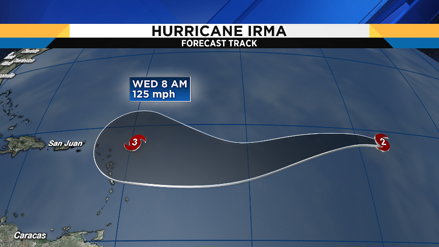
Beyond five days, the forecast becomes very problematic, as we showed you yesterday. Some models take Irma toward the Cuba / Florida area, other models take it toward the mid-Atlantic Coast, other models take it into New England, and there’s still the possibility it can recurve out to sea without hitting anybody. There is a lot of Fake Weather that travels like a wildfire around the internet in situations like this. A lot of weather wannabees see one model that looks particularly devastating, and post that image – hoping that they can later say that they were the first to call it. On most occasions not only are they wrong, but they are also exhibiting very dangerous and irresponsible behavior. Please ignore these “mediaologists,” as we meteorologists like to call them, and know that the Local4Casters will keep you posted with the most relevant information about Irma on Local 4 and ClickOnDetroit.com.
Summer 2017 recap
My friends at Climate Central just crunched the official numbers for Summer 2017 in Detroit, and the numbers may surprise you. On this graphic below, the bottom box in each column represents the bottom 20 percent (either coldest or driest) summer, with each box as you go up increasing 20 percent to the top box, which represents a top 20 percent (either warmest or wettest) summer.
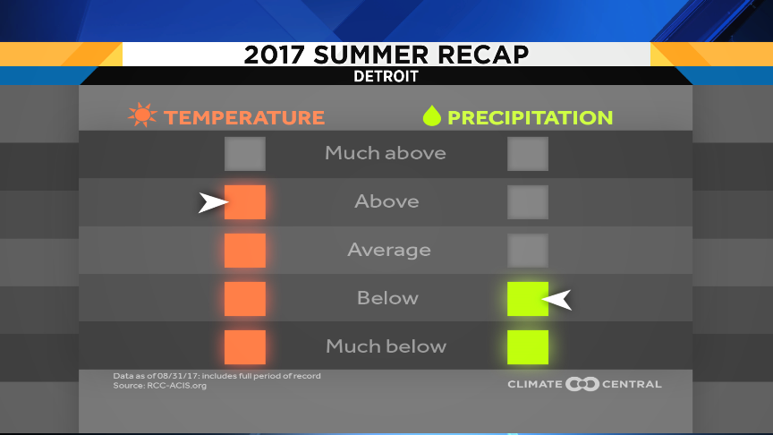
We all know that we had a dry summer…it ended up in the bottom 40 percent of summer precipitation. And keep in mind that a large chunk of the precipitation in June, July and August came from a single rain event in each month. We sure had a lot of dry days (or days with such light rain amounts that it didn’t help) in between those deluges.
However, the temperature may surprise you: as much as many of you will look back upon this summer as a cool one, it actually came in as a top 40 percent warm summer. So how did this happen? Remember that each day’s temperature relative to average is the day’s high temp and low temp added together and divided by two. So, even though we didn’t have as many scorching hot afternoons, we had a lot of very warm overnight lows…and that factors into the computation.

Sign up for ClickOnDetroit breaking news alerts and email newsletters