
No surprises today…unless you haven’t see the forecast for a few days. Rain moved in first thing this morning, right on schedule, and you’d better get used to it: it’s here for a while. The rain will continue unabated through the night, with temps only dropping slightly from where they are this afternoon. By morning, we should be in the mid 40s (6 degrees Celsius). North wind at 15 to 20 mph.
Rain continues through the day on Friday, although it may show a tendency to become lighter and more scattered by evening. Highs in the upper 40s (9 degrees Celsius), but the north wind at 15 to 25 mph will make it feel much more raw out there.
Recommended Videos
Once again, good luck trying to see the sunrise or sunset on Friday. But for those of you keeping track, Friday’s sunrise is at 6:23 a.m., and Friday’s sunset is at 8:37 p.m.
Rain showers are likely Friday night, with lows in the upper 30s, and it remains windy.
Rain showers are also likely on Saturday, with highs near 50 degrees (10 degrees Celsius), and the wind continues.
Total rainfall through Friday night will average two to three inches, although amounts will drop off sharply as you head to the northwest. Here’s my latest expectation for TOTAL rainfall (I modified the model output to my own forecast):

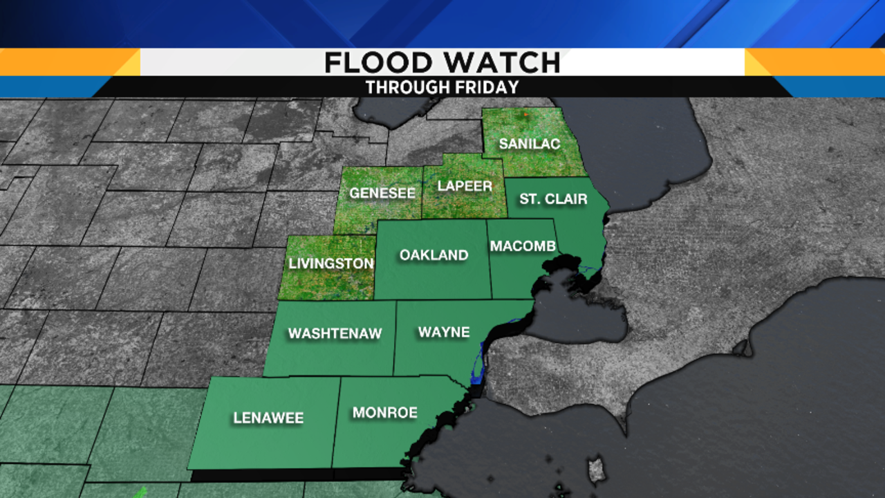
Accordingly, the National Weather Service has issued a Flood Watch for (from north to south) St. Clair, Macomb, Oakland, Wayne, Washtenaw, Monroe and Lenawee Counties through Friday:
Here are some maps from my RPM model showing you the weather for the upcoming three rush hours, into the first half of Saturday (that’s as far as this high-resolution model goes right now):


Rain finally should taper off Saturday night, with lows eventually in the upper 30s (4 degrees Celsius).
Even if Sunday begins mostly cloudy, I think we’ll become partly cloudy, with highs in the mid 50s (13 degrees Celsius), and it’ll still probably be a little breezy.
Skies clear Sunday night and, if the wind slackens enough, this could become a prime radiational cooling night, meaning that temperatures will fall very efficiently. Lows in the mid 30s (2 degrees Celsius) means that those of you in the typically colder places…such as lower spots and rural areas…may have a close call with some frost. Stay tuned.
Mostly sunny on Monday, with highs in the upper 50s 915 degrees Celsius).
Becoming partly cloudy on Tuesday, with highs in the low to mid 60s (17 degrees Celsius).
Partly cloudy to perhaps mostly cloudy on Wednesday, with a small shower chance. Highs in the low to mid 60s (17 degrees Celsius).
After that, it appears that we’ll be dry through the end of the week, although perhaps with not as much sunshine as we’d all like. Highs should be in the upper 50s (15 degrees Celsius).
WeatherFest is almost here – we’re getting excited!