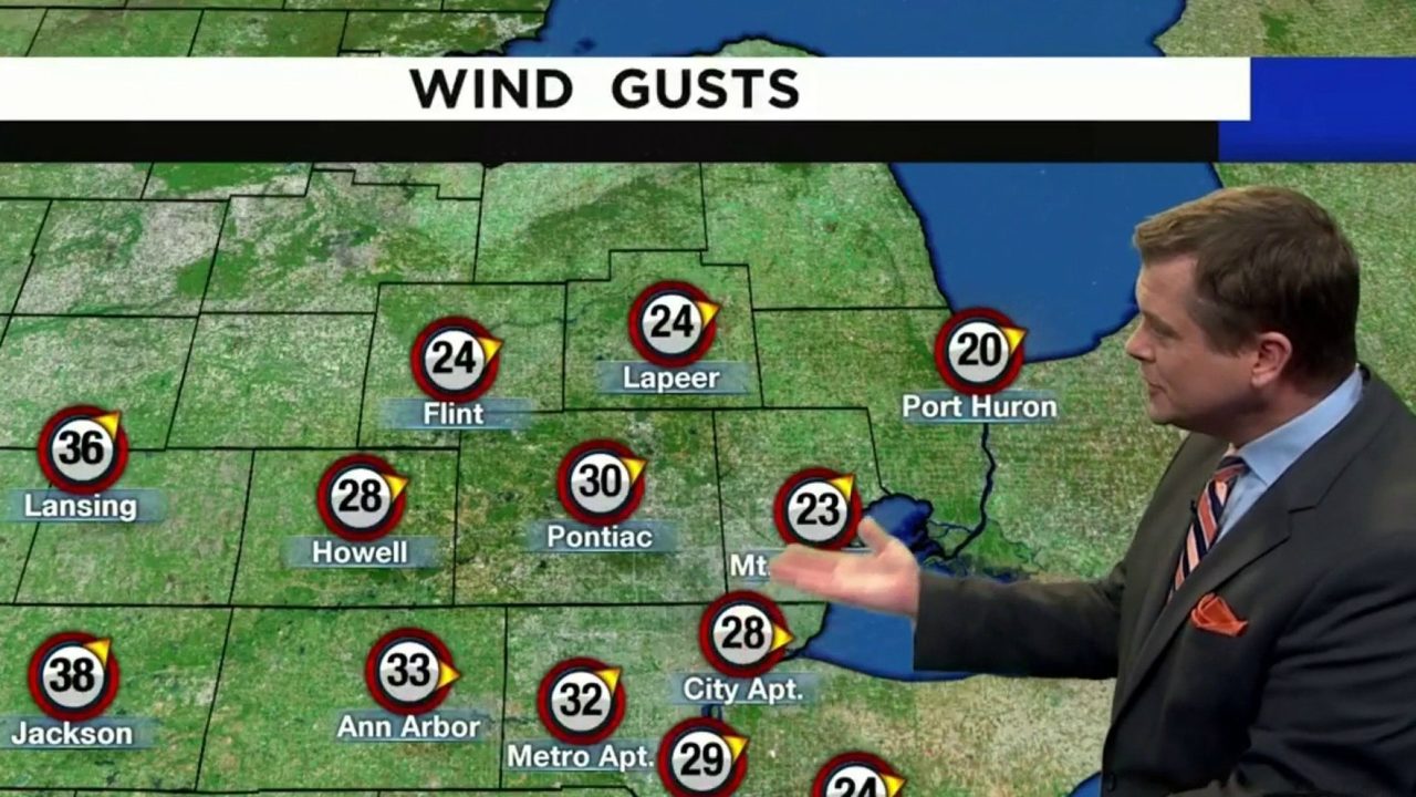
Dry, cool weekend is on tap, with lows dropping at or below freezing in Metro Detroit
Read full article: Dry, cool weekend is on tap, with lows dropping at or below freezing in Metro DetroitMorning lows this weekend will be at or below freezing on both days. Overnight skies will be partly cloudy, with lows in the upper 30s. It will remain breezy with winds WSW 15-25mph.
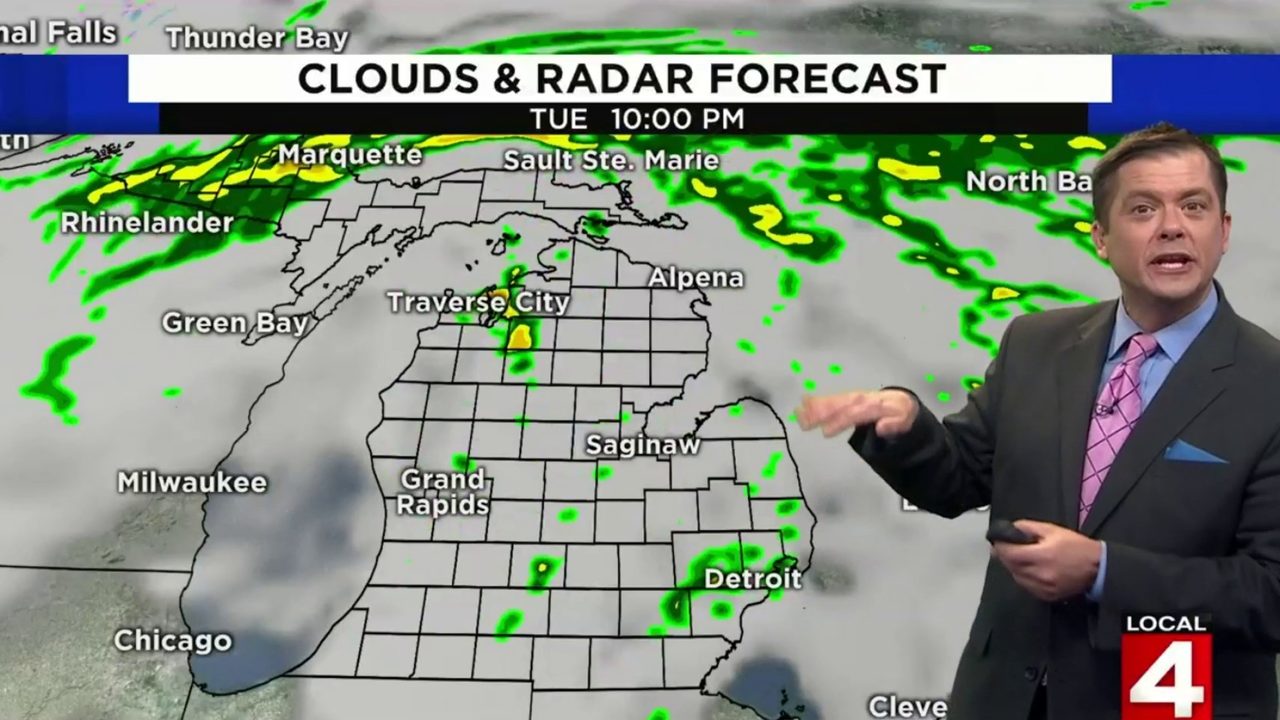
Metro Detroit weather: May brings a spring shower pattern
Read full article: Metro Detroit weather: May brings a spring shower patternGood Monday morning! Scattered, light rain showers are letting up and should vanish from the area which means a mostly dry day ahead for us here in Metro Detroit. Our roadways are in pretty good shape and mostly dry with temperatures in the upper 40s to near 50 degrees as you head out and a steady breeze today WSW 5-13mph making it feel a few degrees cooler. The clouds will be difficult to scour out of our skies even after the widely scattered and light rain has moved on. Expect to see a few areas of low clouds which may leak some drizzle here and there through the mid-morning.
:strip_exif(true):strip_icc(true):no_upscale(true):quality(65)/d1vhqlrjc8h82r.cloudfront.net/10-18-2021/t_d9039b698e04447db664eba880166a04_name_image.jpg)
:strip_exif(true):strip_icc(true):no_upscale(true):quality(65)/cloudfront-us-east-1.images.arcpublishing.com/gmg/TBJPO66CHRCETAGJ25Y2ISGHXI.jpg)
Post-Tropical Cyclone Fred Will Move Off The Coast Of Maine By Early Friday As The Heavy Rainfall Threat Continues To Diminish
Read full article: Post-Tropical Cyclone Fred Will Move Off The Coast Of Maine By Early Friday As The Heavy Rainfall Threat Continues To DiminishAt 1100 PM EDT (0300 UTC), the center of Post-Tropical Cyclone Fred was located near latitude 42.9 North, longitude 71.8 West. The post-tropical cyclone is moving toward the east-northeast near 13 mph...
:strip_exif(true):strip_icc(true):no_upscale(true):quality(65)/cloudfront-us-east-1.images.arcpublishing.com/gmg/AXOWUWXT5NH43J3FUR4M7KO7IA.jpg)
Post-Tropical Remnants Of Delta Continue Weaken, As The Heavy Rainfall Threat Diminishes Late Sunday Night
Read full article: Post-Tropical Remnants Of Delta Continue Weaken, As The Heavy Rainfall Threat Diminishes Late Sunday NightLocation 90 miles S of Knoxville Tennessee Wind 15 mph Heading E at 15 mph Pressure 29.77 Coordinates 84.1W, 34.5NDiscussionAt 1100 PM EDT (0300 UTC), the center of Post-Tropical Cyclone Delta was located near latitude 34.5 North, longitude 84.1 West. The post-tropical cyclone is moving toward the east near 15 mph, and this motion is expected to continue tonight and Monday morning. Maximum sustained winds are near 15 mph (30 km/h) with higher gusts. Some further weakening is possible tonight as a new surface low develops in the Carolinas, and Delta's surface low is expected to be absorbed by this new low pressure area on Monday. Moderate to major river flooring will continue across the Calcasieu and Mermentau river basins in Louisiana through much of next week
:strip_exif(true):strip_icc(true):no_upscale(true):quality(65)/cloudfront-us-east-1.images.arcpublishing.com/gmg/TXFUNM2KFZCTTMJ46TDVK3OYXE.jpg)
New Tropical Depression Forms Over The Tropical Atlantic Ocean
Read full article: New Tropical Depression Forms Over The Tropical Atlantic OceanLocation 1110 miles WSW of The Cabo Verde Islands Wind 35 mph Heading W at 16 mph Pressure 29.74 Coordinates 40.0W, 11.7NDiscussionAt 500 p.m. AST (2100 UTC), the center of Tropical Depression Eleven was located near latitude 11.7 north, longitude 40.0 west. The depression is moving toward the west near 16 mph (26 km/h), and this general motion is expected to continue through Wednesday. Some strengthening is forecast during the next 48 hours, and the depression is expected to become a tropical storm by Wednesday night. Satellite image updated at 03:42 PMWatches and WarningsThere are no coastal watches or warnings in effect. Models image updated at 03:41 PMLand HazardsNone
:strip_exif(true):strip_icc(true):no_upscale(true):quality(65)/cloudfront-us-east-1.images.arcpublishing.com/gmg/ZPIISF7VQNETLJHFZ2IIKFZV34.jpg)
Tropical Depression Forms Over The Central Tropical Atlantic
Read full article: Tropical Depression Forms Over The Central Tropical AtlanticLocation 1185 miles WSW of The Cabo Verde Islands Wind 35 mph Heading WNW at 8 mph Pressure 29.8 Coordinates 40.4W, 9.8NDiscussionAt 500 p.m. AST (2100 UTC), the center of Tropical Depression Seven was located near latitude 9.8 north, longitude 40.4 west. The depression is moving toward the west-northwest near 8 mph (13 km/h). A turn toward the west with an increase in forward speed is expected tonight and Wednesday, and that motion should continue through Friday. Maximum sustained winds are near 35 mph (55 km/h) with higher gusts. Strengthening is forecast during the next couple of days, and the depression is expected to become a tropical storm tonight or Wednesday.
:strip_exif(true):strip_icc(true):no_upscale(true):quality(65)/d1vhqlrjc8h82r.cloudfront.net/02-27-2020/t_b034adbece1f487ab39d739d0b5922ce_name_image.jpg)
Metro Detroit weather: It’s cold -- but not for long
Read full article: Metro Detroit weather: It’s cold -- but not for longDETROIT – The wind is responsible for the impacts of our weather on this Thursday around Metro Detroit. This is frostbite weather if you don’t cover up as those winds WNW 10-30 mph won’t relax until later tonight. FridayWe will wake up Friday with temps in the mid teens and single digit wind chills first thing tomorrow morning. We will see a nice mix of clouds and some sun with a few flurries in Metro Detroit and scattered, lighter snow showers in our North Zone through the afternoon. Remember, your best weather tool any day is the new and improved Local4Casters app, free in your app store searching WDIV.
Metro Detroit weather: Windy Wednesday, potentially wet weekend
Read full article: Metro Detroit weather: Windy Wednesday, potentially wet weekendDETROIT - Our windy Wednesday will be the last of the gusty days for a little while, so try to soak up the sunshine. Some lighter showers are possible closer to the heart of Metro Detroit in the morning hours. Thursday forecastClouds with some spotty drizzle first thing Thursday morning around Metro Detroit, but we're not looking at much moisture here folks. Friday forecastFriday rains will likely land south into Ohio with a chance for a few light morning showers in our South Zone. Unfortunately, light to moderate rain moves into Metro Detroit late Saturday just in time for the Michigan game in Ann Arbor.
Metro Detroit weather: Rain in this week's forecast
Read full article: Metro Detroit weather: Rain in this week's forecastRain chances increase late in the day tomorrow and most of it should hold off until dinner time and beyond. Wednesday rain forecastWednesday looks like the wettest day ahead with those early morning showers becoming scattered rain showers coming and going all day. Temps will likely be in the 40s and 50s all day with breezy conditions too WSW 10-20 mph gusting over 30 mph. We will keep you posted on those next couple of rain chances this week. You can get your 7-Day Forecast and track our next storm chances with our Local4Casters app.

Metro Detroit weather: Cool start in the 40s
Read full article: Metro Detroit weather: Cool start in the 40sIt's a cool start, but wait until you see what's coming Tuesday morning. Rain chances increase late in the day tomorrow and most of it should hold off until dinner time and beyond. Wednesday looks like the wettest day ahead with those early morning showers becoming scattered rain showers coming and going all day. Temps will likely be in the 40s and 50s all day with breezy conditions too WSW 10-20 mph gusting over 30 mph. We will keep you posted on those next couple of rain chances this week.
Metro Detroit weather: Slight chance of light rain as temperatures rise
Read full article: Metro Detroit weather: Slight chance of light rain as temperatures riseDETROIT - Bright sunshine is still sticking around for a few hours in Metro Detroit, and highs are heading into the mid- and upper 70s. That wind will draw in more clouds, but nothing more than a sprinkle is expected north and west of Detroit in the late afternoon or evening. Labor Day weekend forecastEarly morning showers Friday before sunrise and then sun and clouds with mid to upper 70s. There will be another chance for showers early Sunday morning, but we will stay dry during daylight hours all holiday weekend. You can get your 7 Day Forecast and track our next storm chances with our Local4Casters app.
Metro Detroit weather: Hot and muggy, scattered rain possible
Read full article: Metro Detroit weather: Hot and muggy, scattered rain possibleDETROIT - Stay hydrated today with the heat and humidity in full effect as mid or even upper 80s will feel like low to mid 90s. A warm breeze will get a little gusty here and there WSW 5-15 mph gusting to 15-20 mph. That wind will drag lake enhanced clouds and a few afternoon sprinkles in our North Zone Thursday afternoon. Weekend looks niceFriday and Saturday are the best of the week with morning lows in the 50s around all of Metro Detroit and highs in the mid 70s. Sunday is only a little warmer and still dry with highs near 80F as rain chances hold off until Monday and Tuesday afternoons.
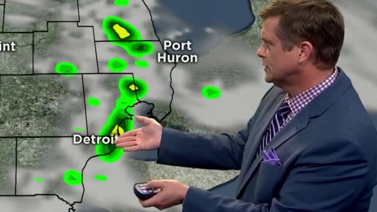
Metro Detroit weather: Spotty afternoon showers, stormy Thursday morning
Read full article: Metro Detroit weather: Spotty afternoon showers, stormy Thursday morningThe cooler changes are on hold which means its going to stay warm for the rest of today. Rain will cool a few of us for a couple of hours but those showers are mainly on the east side and into Southern Ontario through about 3pm today. Thursday and FridayAnother cool front passes through tomorrow morning, and we will see morning showers and storms across SE Lower Michigan and Southern Ontario between 5am and 8am as that front moves in. The afternoon will be dry other than a few random showers closer to Lake Huron in our North Zone. Sunday will go from mostly sunny to mostly cloudy late in the afternoon, but we should stay dry all weekend.
:strip_exif(true):strip_icc(true):no_upscale(true):quality(65):fill(FFF)/arc-anglerfish-arc2-prod-gmg.s3.amazonaws.com/public/EMJHCE2VKRATRET7ACIBTKOS4M.jpg)
Metro Detroit weather: Spotty afternoon showers, stormy Thursday morning
Read full article: Metro Detroit weather: Spotty afternoon showers, stormy Thursday morningThe cooler changes are on hold which means it’s going to stay warm for the rest of today. Rain will cool a few of us for a couple of hours but those showers are mainly on the east side and into Southern Ontario through about 3pm today. Thursday and FridayAnother cool front passes through tomorrow morning, and we will see morning showers and storms across SE Lower Michigan and Southern Ontario between 5am and 8am as that front moves in. The afternoon will be dry other than a few random showers closer to Lake Huron in our North Zone. Sunday will go from mostly sunny to mostly cloudy late in the afternoon, but we should stay dry all weekend.
:strip_exif(true):strip_icc(true):no_upscale(true):quality(65):fill(FFF)/arc-anglerfish-arc2-prod-gmg.s3.amazonaws.com/public/Q2N77H7O6FHXBNHYXFJMX3HZSM.jpg)
Forecast: Cool, dry, sunny Wednesday in metro Detroit
Read full article: Forecast: Cool, dry, sunny Wednesday in metro DetroitDETROIT – Cold air is with us all day, but at least we're getting some sun and lighter winds. Those clouds help temps from dropping too cold overnight as we should see lows staying in the low 20s. Thursday forecast:Metro Detroit will have low 40s on Thursday but not until late afternoon and evening. Friday forecast:There will be scattered light rain early part of Friday before it clears in the mid to late morning. Highs in the upper 40s will come early as cooler air rushes back in through the afternoon.